

Irma, cat 2, is undergoing an eyewall replacement cycle
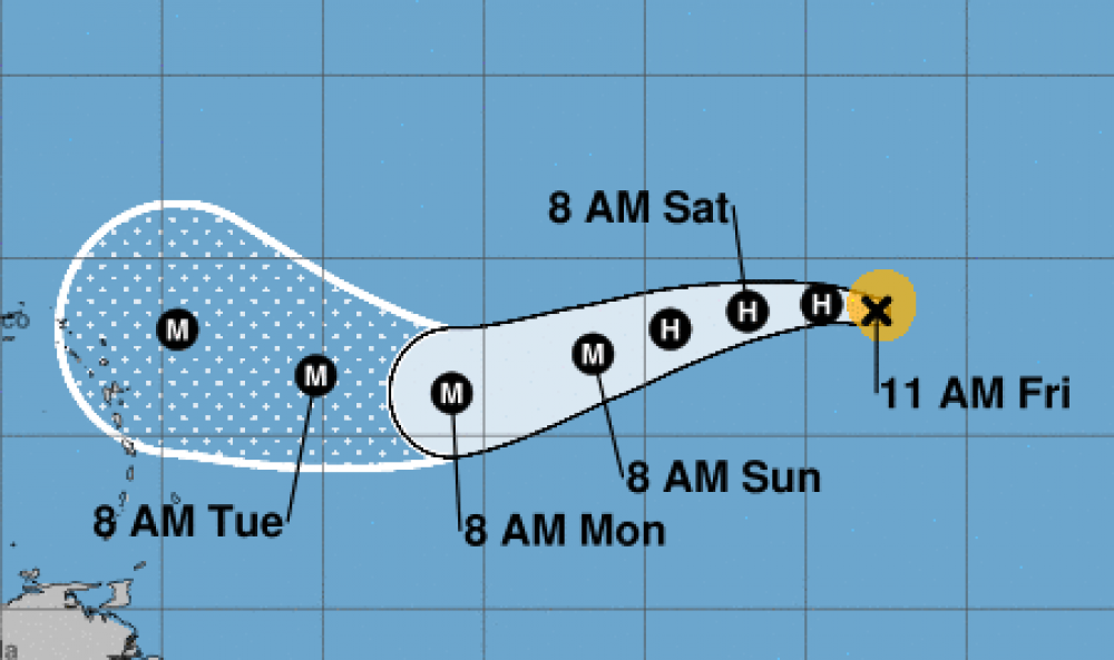
Irma is undergoing an eyewall replacement cycle. The small eye is becoming less distinct, with both microwave and visible imagery indicating the presence of a forming outer eyewall. Satellite intensity estimates are lower, so the initial wind speed is reduced to 95 kt. Some further weakening is possible over the next day or so while Irma moves over marginally warm SSTs and continues the eyewall replacement. After that time, the environment should be generally conducive for some restrengthening, although forecasting the timing of eyewall replacement cycles is next to impossible. The biggest change from yesterday are the long-term wind shear predictions from the global models, which shows a little more shear. Still, the shear is not that strong, and the hurricane will be moving over 29C SSTs. Thus, the NHC intensity forecast is reduced somewhat from the previous one, but remains near or slightly above the model consensus. Irma has turned a little bit to the left, now estimated to be moving 285/11. The general synoptic situation remains well established due to a building mid-level high, which should cause the hurricane to turn westward later today and then move west-southwestward through the weekend. An upper-level low will be dropping southward on the east side of that high, and should be a key feature to how far south Irma goes before eventually turning westward and west-northwestward early next week. There is a noticeable clustering of guidance by day 5, with the ECMWF, HWRF and corrected-consensus models to the south, and the UKMET, GFS, CTC and HMON to the north. Since Irma is forecast to be a vertically deep cyclone, it seems more likely to respond to the northerly flow from the upper-level low, which leads me to believe the track will be on the southern side of the guidance. Thus, the forecast will stay similar to the previous one, very close to the southern cluster mentioned above.